After seven days in Yosemite, I’m getting back to this dubious business of living in the “real world.” Back to emails, and voicemails, and stacks of snail mail, and TV shows sitting on the DVR (well, those I’ll take).
But in between all of that, I’m starting the daunting task of downloading, browsing, and editing all my pictures from the last week… a few hundred of them off my camera and the hub’s camera, from our entry trailhead at May Lake in the High Country all the way to our exit trailhead at Happy Isles in the Valley. (More from those in a few weeks… if I’m lucky!)
The impetus for this trip was my friend finding out back in April that she’d won the Half Dome lottery to climb the cables. We were excited but hesitant about the 16-mile hike… while completely doable, it didn’t sound very appealing to hightail it in and out of the valley in a span of 12 hours. So Will and I decided to turn the opportunity into a trip we’d always wanted to do: one week in the Yosemite backcountry, culminating in the climb up to Half Dome.
We would camp in Little Yosemite Valley (the closest starting point to Half Dome) and have a leisurely hike to the cables the next day, reducing our round-trip total to just 7 miles instead of 16. And, we’d have the freedom to go at any time of day, rather than being limited to a sunrise start time like most other people doing the in-and-out in a day.

On a Monday afternoon, we were incredibly lucky to be the only ones on the cables and have the whole dome to ourselves. After making it to the top and back, I’ll be the first to admit: I highly underestimated Half Dome.
I knew a few friends who’d climbed the cables, and I’d remembered seeing pictures of kids clambering up the slope and ultralight hikers wearing their “barefoot” shoes on the approach, all of which made it seem like Half Dome would be a walk in the park.
But I also think quite a few people bail on their permits, or reach the base of the dome and then turn back. If anything, the hike up the subdome seemed far more strenuous than the cables themselves.
There wasn’t a ranger to check our permits that day (at least, not that late in the day by the time we got there) and it seemed like everyone was coming down the same moment we were going up.
The first haul up Half Dome (on a section called the subdome, elevation 7,900 feet) was a series of steep switchback stairs carved out of the granite, some of them over a foot tall.


While channeling our inner mountain goats, we had views over the entire eastern side of the park, including a peek at our previous campsite on top of Cloud’s Rest.


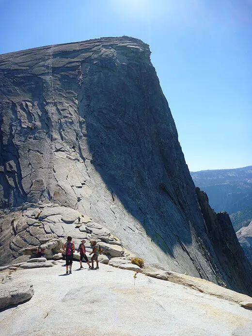
About 500 feet of vertical later, we reached the base of the cables. In front of the route lay piles of old leather work gloves, free for the borrowing.


The cables loomed 400 feet up a granite slab, worn smooth from thousands of hikers ascending this same route over and over again for the last 90-some years (when the cables were first installed). Looking up, my first thought was… What the f@%k!?

The route seemed to disappear straight into the sky, at a much steeper angle than I’d expected. I’d assumed the cables were only in place as handrails of sort, but with the slope angled at 45° to 50°, you definitely needed to use the cables to climb the whole way (and good, grippy gloves are a godsend). Not only that, wear great shoes and trust your feet… and maybe do a few chin-ups or push-ups to prepare yourself, because that’s pretty much what you’ll be doing for 400 feet.
Every 10 feet or so, poles were put in place with flimsy little wooden boards on the granite to help you gain some footing. Climbing the cables took a lot of upper body strength, but if you focus on just taking deep breaths, moving from one board to the next, pinning your feet against the poles for support as you ascended, it was a manageable feat. (Some people harness up and clip in to the cables as they climb — via ferrata style — but I don’t think it’s necessary unless you’re really afraid of heights.)


I can’t imagine what the cables must have looked like earlier in the day when throngs of tourists were moving up and down the dome, or what the route used to be before the permit system was in place. To climb the cables with hundreds of other hikers in front of you and behind you seems like a nightmare. I’d read stories of hikers getting aggressive or impatient, or trying to pass the slower hikers, or even climbing outside of the cables — seriously? There are no mistakes on Half Dome. Getting cocky on the cables is a sure way to take yourself out or even worse, take someone else out.
So with our group of seven, I was so grateful to be the only people climbing up the route that time of day. We took our time, giggled and chatted, and enjoyed the views over the park. All of us made it to the top with a final exhilarating scramble to 8,840 feet above the world!


It’s rather unbelievable that no one was on the summit with us, and we still had a few hours to spare before sunset. We had Half Dome to ourselves! What amazing luck. We rested, snacked, took pictures and made friends with the resident marmot.


This little guy (one of many yellow-bellied marmots in Yosemite) was curious and mischievous, and you could tell he was used to human interaction. He walked right up to us, posed for pictures, and we even found him snooping in one of our packs. We gave him some water and named him Hal F. Domé. (Cheesy, I know.) He definitely needs his own Facebook page!


After spending a couple of hours at the top, we started making our way down the cables with plenty of light left in the day. Because of the steepness, it was much easier going down backward. By the time we reached the last 30 feet of cable, we could turn around and simply walk down the slab facing forward.


We practically skipped back to camp in Little Yosemite Valley, and just after the sun set, we threw ourselves into the (very cold but very refreshing) Merced River for a celebratory soak.
Half Dome… success! Another one to cross off the life list! (And if you’re looking to cross it off your own list, this is the best map and guide I’ve found that describes the trail and its history.)
Trail map: Click here
Segment log: 7 miles with 5,380 feet elevation change
Next segment: Little Yosemite Valley to Happy Isles and home sweet home
Read the full “Epic Yosemite” series:
- Backpacking to Raisin Lake
- The Start at Tenaya Lake
- Sunrise Lakes to Cloud’s Rest
- Cloud’s Rest to Little Yosemite Valley
- Climbing the Half Dome Cables


Your trip looks AMAZING, and we have one planned in June following a very similar path after reading your posts and seeing all the incredible pictures. My big question – did you have a couple cars between your start and end points? I can’t figure out how to get back to my car! I can see a tour shuttle/hikers shuttle, but I am curious if it is recommended to go out with a car at trailhead where we start and where we plan to end?
It’s quite a long drive between the valley and the high country, so we parked our cars at the trailhead (at Tenaya Lake) and took the park shuttle back on the last day. You just have to make sure you finish your hike in Happy Isles while the shuttle is still running (and definitely call ahead to check, in case they don’t run it for whatever reason).
Thanks so much!! That is what I was planning to do, so I’m glad I was on the right track with thought process. I wanted to make sure I’m not missing anything that I couldn’t find online, etc.
Hwy 120 (where Tenaya Lake is) most likely won’t be open until Mid to late June at the very earliest and the high country will be buried in snow. Snow Pack at Tioga Pass is enormous this year just a FYI
I have loved reading your posts about this trip! We are doing a very similar route in just a few weeks. What time of year was it when you did this trip?
We went in late June or early July.
Wow GREAT photos! I’m doing this hike for the first time on July 3 of this year. I doubt I will have it to myself because it is a holiday weekend. Still what time did you start your hike to the cables? (maybe I can figure out a way when there are less people). Also how is it getting down? And is Cloud’s Rest out of the way? I’m really excited and love the post. Good job!
We camped at LYV the night before, so we were able to start late in the afternoon after everyone had left. Most people who hike the cables start early and leave early to make it back to their cars before sundown. Getting down was the same as going up… I imagine we had it easier since there weren’t any people on the cables. I’m not sure what you mean when you ask if Cloud’s Rest is out of the way; it depends on your route and where you’re spending the night.
Great post!! I have a long and arduous tale to tell of my ordeal with getting to the cables from Tanya, lost on a wrong turn ending up at Cloud’s Rest, lamenting where I still had to get to, back tracking, alone, gathering blisters under my toenails and on and on…anyway, that was 1979, when things were far less crowded, no convenient pile of gloves, and you failed to mention how polished the granite between the boards is and how it may just seem like ice at times.
Admittedly I was exhausted and may be being a bit melodramatic in memory, but, for sure, don’t take the up and down from the valley lightly and surely not the cable ordeal…lotta work, and TAKE WATER!
Great share. Your photos really gave me a better idea of what I’m facing. Sadly – I think I’ve hit the too old wall. I’ve entered the lottery but will have to give it more contemplation!
Too old? Never! 🙂 Slow and steady is what I always say.
Thanks for sharing. I’m just back from a weekend in Yosemite, and planning the next trip – including a hike up Half Dome. It was great to read all the details of your trip!
A late fall trip to Yosemite sounds beautiful! (I’ve visited on all the seasons, and still have trouble picking my favorite.) Enjoy your next one!
when I got to the base of the cables I definitely hesitated, it took me a few minutes to gather the courage and I am glad I went the distance!! It was an emotional feeling on top! Just spectacular!
The utter relief and sheer joy at the top can’t be beat! I think my adrenaline rush came AFTER I was done climbing!